Alderfer / Three Sisters trail run

Saturday January 7th

I haven’t ran in 2 months. Between holidays and getting sick twice, November and December have not been kind to me. 

I almost bailed Saturday morning. I woke up feeling poorly, but decided I had to stick to the plan.

This is why I make plans and goals. It’s harder to waiver if you’ve already made a commitment to yourself.

Some Starbucks and an hour drive later and I was so glad I stuck to my plan. 

Good morning Colorado, hello sky. 

If you want to experience a glorious yet manageable, aka short, trail run, Alderfer Three Sisters park is a great place to do so. 

Made up of lots of short trails, it’s easy to string a run together in your range. 

Remember that if you’re doing a trail run, it’s harder than running on the street. And if you’re running in the snow on a trail it’s twice as hard as that. Set your running goal based on that assumption and don’t be dissappointed when your run takes quite a bit longer too.

The official Alderfer Three Sisters website. 

Trail Run project summary. 

Have fun and keep safe out there!

Golden Gate Canyon – Mule Deer and Coyote Loop – Trail Run Review

Hello! It’s been a while since I’ve posted. I might do some retro-active posts. But this one will be a special combo, a look at the same trail loop that I ran in January 2016 and again this past weekend (August 20th, 2016)!

This run starts at the base of the Blue Grouse Trail (39.836499, -105.430711) , goes right up Mule Deer, cuts left up Coyote to some beautiful rock outcrops with a hard scramble down, and left back onto Mule deer. Eventually turning right again on Blue Grouse back to the parking lot. It’s about 7 miles total.

In January, I braved the cold and went out for a run. My planning was much poorer than normal. I had done several winter trail runs at this point and was overconfident. When I got to Golden Gate Canyon State park, I checked in with the ranger at the visitor center. Her look of astonishment as I explained my planned route was my first hint that I might be crazy.

I continued on my merry way where I encountered 17°F with an icy breeze. This was by far the coldest run I had ever done or have ever done since. By contrast, running in August was a delight. A high of 62° and just beautiful!

The snow was from a week prior, but the wind kept blowing it over the trail… As you can see, identifying the trail was almost impossible. I used clues like the snow being more firm in a line than side-to-side and spotting gravel near tree wells.
This is where I really realized how stupid I was. I was cold, I couldn’t see the trail, the snow was blowing over my footprints behind me, there was no phone signal and I knew a snow storm was supposed to come in around 2pm. I was lucky that day. And I learned how stupid I could really be. I continued on, taking it on faith that it was faster to go forward and I would be able to find my way with the many trail markers.

This picture is me looking at what I thought was the trail…

Same crossing in summer and winter. Oh my gosh! There’s a parkimg lot there! Off of a road that’s only open in the summer.

Gorgeous winter panorama on the run back, about 12:30pm. See the clouds peeking over the hill to the right? That’s the 2pm storm coming in. I outran it, but I stopped taking the time to take pictures!

Same panorama (almost) in summer.

In conclusion – this trail is gorgeous and fun in the winter (with traction) but take a gps! And be a lot better at orienteering than I am.

In the summer, pure perfection. It’s close to the city, but high enough up (8000-9000ft) that it’s 10° cooler than the city on average. 

It’s a good 1200′ climb up to the top of coyote trail, then a nice slow slope down in the valleys that will help you get a nice fast pace.

Remember that state parks require to have a parks pass or pay for a day pass. You can pick up a day pass at the visitors center on the way in!

Have a great time and be safe out there!

Deer Creek Canyon Park – Trail Run Review

My first time trail running in the snow! I went to Deer Creek Canyon Park the weekend before Christmas.

It had snowed about 10″ five days prior, but it was in the upper 40’s the previous two days and most of the snow was melted at our house. It was supposed to be in the mid-50’s that day and I assumed (incorrectly) that most of the snow would melted on the trail. So I wore my normal trail running shoes.

The result was that I couldn’t keep a good grip and worked 3x as hard in twice as much time. So I had to cut the run shorter than I planned. But it was still a great time in a winter wonderland!

This run ended up being about 7.4 miles long if you follow my shortened story below, or 9.9 miles if you follow my original route plan.

image

I print maps, shrink them and bring them with me. I tend to get lost in thought and get lost in real life too!
image

I got to the parking lot around 10am. It wasn’t too crowded but there was a surprising amount of people for all the snow. This is probably pretty popular in the summer.

I headed up Meadowlark trail, slipping and sliding the whole way.
image

Almost immediately, some beautiful vistas became visible.
image

The winter sun made some really pretty contrasts. Here it looked like I was going to run over a cliff! Or head into a parallel universe where it’s night.
image

Meadowlark trail headed down into a hollar where it crosses a bridge over Plymouth Creek and joins Plymouth Creek trail.
image

image

Unfortunately the trail became pretty steep at this point. This is where it really became apparent that my trail shoes were not going to cut it.
image

My original plan at this point was to head up and around Red Mesa Loop. But as the climb continued and I couldn’t get a grip, I decided it would be best to cut back left at the Homesteader Trail. Unfortunately, again, I missed the cutoff.

If you’re looking for the Homesteader Trail, keep looking up and over your left shoulder. The trail is hidden around an embankment from this direction

So anyway, I passed by Homesteader Trail and didn’t know until I reached the beginning of the Red Mesa Loop. Sigh.

This is what the Homesteader Trail looked like when I came back down.

image

Homesteader trail was awesome! Beautiful! Way less traveled than the other trails. Which means… way more work.
image

image

Eventually, I hooked into the Plymouth Mtn Trail. Stay right or you’ll head back up to previous trails.

I passed where Black Bear Trail connects in. That would be a fun trail to do one day, but for now, it didn’t look like it was open.
image

image

Black Bear trail to the right. Plymouth Mtn Trail to the left

I came back to Plymouth Creek Trail, it looks different from the other side!
image

I headed right to go back. This was a slippy slide down!

image

One last look! Phew! I need some traction next time!

San Diego Bay – Sunset Run

In early December, I had to be in San Diego for business. It was a tight schedule, but for an hour I got away for a quick run along the bay!

image

image

image

image

image

image

image

I tried to make it out to the ocean, but a local hotel had blocked the path. Rude! So this was all I got. Not bad for a short run! It felt amazing to run at sea level, so much oxygen!

Juarez and an Irish Pub

Quick post about my trip to Juarez, MX. I went there for work, not a pleasure jaunt, but it turned out to be pretty fun anyway!

We went out one night, to an Irish Pub… in Juarez, MX. I’ll let that sink in for a moment.

At that Irish Pub was happy hour (Buy 1, get 1!) and a flipping fantastic 80’s cover band.

image

image

image

image

They’re probably a local band. They were so good though… if I knew their name, I would pay to see them again!

Moab Trail – Half Marathon Review

Finally! The reason for the season. What I had been working towards all summer (but let’s be honest, had only really kicked into gear in August/September)!

The Moab Trail Half!

Two disclaimers- H15l337n355’s parents are in the “Moab Friends-For-Wheelin” club that volunteers and benefits from this race…. And this was my first half-marathon and first trail race. I am a glutton for punishment?

I have run quite a few street 5ks, a couple 10ks, and a 15k though. So at least I know what a race should look like.

Let me start off by saying that this is going to be a rave review. I had so much fun and saw so much beauty… How could it not?

I won’t put the trail map here, you’ll have to go to their site for trail details. Oh! And check out the sweet video footage from the 2014 run. That’ll give you a good idea of what really awaits you!

We (my friend Becky and I) got there about 45min before our wave. There was ample parking and you could camp there the night before if you wanted. It was a long-haul walk from the parking lot to the start. Just think of how good the cool-down will be after the race.

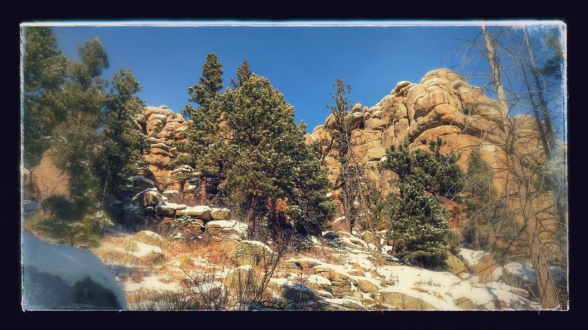
It was a crisp, chilly 30°F, so after a quick pit stop and saying hello to Lydia (my SO’s mom who was volunteering at the registration desk!) we went to warm up by the campfire that was in the middle of everything. We peered around at our surroundings. The start is near the Colorado River and the cliff walls tower across the way.

Soon it was time for our wave (Becky was sweet enough to run in the back with me. Thanks Becks!!). We took off down the road, around the corner and up the trail.

The first couple miles are a blur to me. I remember how much fun it was to jump and run over solid rocks instead of Colorado skree (don’t be mad at me Colorado, I still love you best!).

Eventually we started up the steepest incline of the race. Where we pauses to take this selfie. Can you see the gorgeous panorama behind us?

image

This is the only photo I have while I was still so bundled up. I took off my coat at the first aid station. (5.7 miles)

The first aid station had rockin music, snacks, water and sports drink. Oh, and my lovely SO, h15l337n355, and Warren who had gotten up and going at some god-awful hour (much earlier than me) to jeep out to the aid station to volunteer. Thanks guys!!

image

The sand on parts of the trail was so fine and so soft, it was brutal to run through. I don’t know who that person was in front of me, but I know how they felt!

image

image

Hey! There’s a view here! Take a pic, quick!

The most beautiful part of the race was Hunter’s Canyon rim before the second aid station. It was so beautiful that I didn’t think to take any pictures! Darn it!

We ran right on the edge of the canyon and had to do some fun rock scrambles. It was fun and scary! People hurt their ankles here. Be careful!

At the second aid station, they had even more snacks, water and sports drink.  At this point the marathoners split off to the left and the halfers went to the right. To the right was a disappointingly steep road that seemed to go on forever.

But eventually it ended where we hopped into an icey cold creek that went on for a mile or so. If it sounds like I didn’t enjoy this… Let’s just say I really like how bad-ass I felt about it after. (I did a half-marathon where a mile of it was wading through a creek?! I am awesome.)

image

Don’t be deceived. This is just the part I felt comfortable taking my phone out on. It would have most likely fell into mud and been ok at this point. Prior to this it would have fell into a foot of water I couldn’t see through.

The run finishes up with a singletrack that crosses this creek a couple more times. And just when you think there really are no more up hills, there’s a brutal embankment to climb up right before the finish. But finally, we were done! Hooray!

image

We picked up our finisher medals, some hot soup and cheese quesadillas (seriously genius!).

I have to say that I thought the organizers did a great job. The waves left on time and they were spread out enough to reduce bunching. The shirts were nice, the medals were pretty. If you’re the type to be competitive, I saw the trophy’s and they were so cool! There was plenty of food and drinks for everyone. The atmosphere was a party atmosphere.

Remember to bring your ID to registration, they’re pretty strict about that (since only so many people can run on this course and they have a firm wait list system). 

I recommend bringing a change of shoes and maybe some warm clothes. After you run through that creek you’ll want them!

This is such an amazing race. I can’t wait to do it again next year! Maybe next time I’ll remember to take more pictures!!

Roxborough State Park – Carpenter Peak trail run review

I know! It’s been too long! Here’s what I can remember of this run, that happened on October 31st.

First, I was really excited to run on Halloween with Zombies, Run! I don’t think I’ve mentioned this app before. I’m in season 2, so I was able to run all the Halloween missions on Halloween! If it hadn’t been so bright and sunny out I would have been much more creeped out than I was. As it was, the lonelier parts if the trail gave me a little too much time to think about these creepy stories.

I need to do a completely different post about Zombies, Run! I could go on for days about how much I love this app and I probably should talk about the trail run I named this post for. 😀

First, Roxborough State Park is a state park, so fees apply if you don’t have a Season Pass. Day park fees are $7/vehicle. A season pass is $70 and can be bought online at anytime of the year. A season pass lasts for 1 year starting the month you buy it. Totally worth it if you plan on visiting any of Colorado’s state parks on a regular basis. Plus, you’re supporting Colorado State Parks! Something I’m a big believer in.

I got there late, around 10am and the parking lots were filling up. I parked in the lower lot and made a bee-line to the restrooms. Roxborough doesn’t allow cyclists, so you’ll have a lot of short day hikers. It’s actually incredibly nice not to worry about cyclists running you down. I did hurry to get on the trail before a group of boyscouts though.

I took a moment to grab this awesome photo of the setting moon above some red rock formations near the visitors center!
image

image

I took the yellow highlighted route. Starting at the visitor center towards Carpenter Peak along Willow Creek trail.

The Willow Creek trail is rolling and pleasant in the shae of the trees. Soon though, you’re heading up towards Carpenter’s Peak. As soon as you get a little higher, you’ll start seeing views like this:

image

Gorgeous!

I personally love feeling like I’m alone in the woods. This is from the last stretch before the peak. A nice shady break from that sunshine.
image
Sorry for the grimace, apparently I don’t know how to smile. Ha!

Hooray for the peak! It’s all downhill from here. Right??
image

I headed down from the offshoot that is Carpenter’s peak and took a right towards Waterton Canyon (don’t worry, we’re not actually going to Watertown Canyon, it’s closed for bear activity. Though, when it’s open again that would be a really fun run. Just get someone to pick you up on the otherside!) along Powerline Trail.
When you see this sign, go the other way. Yikes!
image

Powerline trail was very cool and very empty of people. At times I was really worried I was lost. I kept seeing signs that I was leaving Roxborough State Park, but then I’d be back in a couple minutes later. This trail weaves in and out of the park and into national forest. You might run into some cyclists here, I didn’t run into many.

Beautiful dappled sunlight along Powerline Trail.
image

Eventually, you’ll come across a trail that goes to the right. This is where I met the only cyclists I saw. They were all taking a break. The unmarked trail to the right goes to the Indian Creek campground. Stay straight to keep on the trail that returns to Roxborough.

Keep an eye out on the left, higher up on the bank will be a sign saying “Visitor Center this way”. Make sure you take that left! Otherwise, you’ll end far out in open space!

Beautiful formations on the way back:
image

image

I decided to add just a little bit extra onto my run and take a right onto the Willow Creek trail. I was glad I did. This was an easy last 1-1.5 miles and had stunning prairie views back towards the rock formations.

image

image

After that, I found my way back to the parking lot. I think the park map mileage said I would complete 7.8 miles and it ended up being closer to 10. I think the “Carpenter Peak” loop on the website does not include the “Powerline Trail” like you would assume.

All-in-all, I thought this was a great run to end my training on before the Moab Trail Half-Marathon. The lack of cyclists and the lesser used paths really give you a good sense of nature around you.

Let me know if you end up running any if the trails I talk about! I would love to hear your take.

North Table Mountain Trail Run Review

Last weekend I went up to North Table Mountain in Golden to trail run.

image
The pink highlight is my route.

I got there at about 9:30am and the parking lot wasn’t as full as I was worried it was going to be. It was about half empty still and I found a spot easily.

One difference I noted about this park is they rate their trails like ski-trails. Black diamond being the most difficult, Blue squares are moderate, and Green circles are easiest.

I made a pit stop at the bathrooms and then headed up the trail on the right of the bathrooms. Woowee! That black diamond marker was no joke. A steep incline that took me about 15 minutes to walk, yeah walk not run, about a half mile to the top of the Mesa. That climb was brutal.

Once up top, the sign markings get a lot clearer. I turned right to stay on the North Table Loop. You’ll see some really cool cliffs and beautiful Vistas. The trail will take you back down the side of the Mesa.

image

Eventually I turned left up the Cottonwood Canyon Trail. This is another steep ascent, switchbacks this time.

Keep an eye on you surroundings. This whole area was chock-full of cyclists when I went through here.

When I got to the top, I saw what I think was a baby rattlesnake in the middle of the trail. Trying to warm up it’s torpor. I didn’t see it till fairly late and jumped over it. I didn’t think it was a rattlesnake at the time and I was worried that the little guy was going to get ran over by a cyclist. So I scuffed some gravel in his direction to get him up and moving. He reared up and started hissing and shaking his tail. I stayed back and kept at it. He shimmied off the path and I moved on. I warned the next folks that he was there. Later, H15l337n355 told me it might have been a rattlesnake. I didn’t realize that baby rattlesnakes don’t have rattlers! The more you know! I did some googling and will be more prepared next time!

I turned left Mesa Top Trail and right on Rim Rock Trail. Rim Rock Trail takes you up to the peak of the Mesa and to some pretty cool views.

image

image

image

After the peak, I headed back down. This loop was my favorite part of the run. Beautiful prairie and beautiful views.

A small bridge in the sky!
image

I saw the portion of the trail that had been closed due to flood damage. So I turned right back onto Mesa Loop Trail and then left back down Cottonwood Canyon Trail.

I took a left at the North Table Loop Trail and got some good views of the Coors Brewery from up top.

image

And a view of Denver in the distance!
image

I stayed on the North Table Loop trail all the way back to the parking lot. At this point the trail is moderate and then ends easily. A nice run out to end on.

All in all, I thought this was a great trail run. Challenging in spots, enough beauty to keep you interested but not stop you too often, and enough flat areas to get some speed going.

Enjoy our beautiful Colorado!

Mt Falcon Trail Run Review

Last weekend I went up to Mt Falcon park to run. Click here to go to the park website.

Yellow is my run out and pink is my run back!
image

I came in the east entrance at 9am. The parking lot wasn’t too crowded, I got front row parking.

I started up the trail and almost immediately the trail got really steep. I took the Turkey Trot trail up which is great because it’s hiker only, it’s shady and has some great views of Red Rocks in the distance.

The Turkey Trot trail rejoined the Castle Trail. I continued up to a shelter and took a right to go the Summer White House site.

image

Here you can read the historic plaque about Walker’s dream of a Summer White house funded by Colorado. There’s also the white marble cornerstone for what would have been a crazy gothic castle. And, of course, you’ll see some gorgeous views. That’s why this site was picked, after all.

After that I continued up Castle Trail and left onto Meadow Trail. This next part was my favorite part of the trail. The crowds thinned and the trail was beautiful. I passed some awesome benches, that I need to make for home. I just need some straight up logs!
image

I continued onto Old Ute Trail (gorgeous!) And out onto Devil’s Elbow. Beautiful views of Denver again.
image

I headed back up the loop and up Tower Trail. Finally the actual summit, which includes a small tower and more beautiful views.
image

Next was Eagle Eye Shelter, which is a summer cabin built by a family in 1918 after Walker left the area.
image

I continued and turned right on Castle Trail and finally encountered the Walker Home Ruins. These ruins are the remains of the Chateau built by Walker for his wife and family. So cool!
image

image

image

I headed back down Castle Trail, this time skipping the Turkey Trot trail and sticking to the main one. That was a mistake. Tons of cycling traffic, some of it wild and crazy as some folks took full advantage of the downhill.

This was a very cool hike with tons of great sites to visit. I don’t think it was a great trail run though. Too steep, too busy and too many distractions to make for a good run. My recommendation? Go in the west entrance with some friends or family that don’t want to work too hard, see the sites, save the running for somewhere else.

Elk Meadow Park trail run review.

At the beginning of October, I made the 45 minute drive out to Evergreen to trail run in Elk Meadow park and summit Bergen Peak.

Visit the park page here.

The yellow highlight is my route with some out and backs and a large loop. I entered the park through the Lewis Ridge Road entrance.

I got there around 11am (late) and had to park on the side of the road.
image

I did 12 miles in this park. Well, correction, I planned on doing 12 miles but actually did 11.5. I cut off the last half mile after I twisted my ankle.

The main point of this park (harhar) is Bergen peak. I did spend a couple miles in the meadow before I started to ascend, which was a nice warm up. It would have been fairly easy but the wind was blowing like crazy. I had to take off my hat and hold onto it so it wouldn’t blow away!

While I was running across the meadow trail, I spotted a man walking his llama! The llama’s name was Honeybear. I didn’t catch the man’s name. I blame Honeybear’s cuteness for my lack of concern about other people.

Me and Honeybear

image

Then I headed up Bergen Peak. It was a steep 2500 ft elevation change. There wasn’t a lot of actual running up the peak. The cycling traffic was intense. If you try this run, make sure you keep an eye and an ear out for the cyclists!

The views from the peak are gorgeous. You can see Denver, and you’re a good 45 minute drive from it!

image

There’s Denver!

image

Woohoo! I made it! Now I can head down! The easy part!

image

Some bright yellow aspens!

image

The way down was tight with lots of rocks in the trail and sliding skree. Be careful! I twisted my ankle twice and fell once. My aching ankle made me take a slight shortcut on the way back.

This was a really fun run. The views and the weather were beautiful. The cyclists and the sliding rocks were treacherous though.

Make sure if you hike or run alone to use an app like Road ID to alert someone to your whereabouts and send an alert if something happens!